
Walk a St. Louis Street
A St. Louis address can open several distinct record paths. The City Address & Property Search supplies the parcel and its assessment context. City GIS then places the parcel among blocks, wards, neighborhoods, ZIP areas, and city limits. The Recorder’s index connects a current owner to recorded instruments. Historic reverse directories can add an earlier address clue. A registered-voter record is a separate, restricted verification source, not a street roster.
Start with an address inside the independent City of St. Louis. A nearby mailing address that says St. Louis may instead be in St. Louis County, whose recorder, assessor, election authority, and court system are separate. That boundary check prevents the common mistake of ordering City records for a county parcel, or the reverse.
- Enter the normalized address or parcel in the St. Louis City Address & Property Search. Save the situs address, parcel ID, collector account, owner field, owner mailing address, legal description, and map links.
- Use the City’s GIS boundary layers to place the parcel on its block. Turn to individual addresses along the street rather than assuming the map is a people database.
- Open Recorder DirectSearch with the current owner, legal description, address, parcel, or book and page. Record the parties and instrument details before moving backward.
- For a qualifying voter verification or a lawful record request, use the Missouri Voter Outreach route and City election guidance. The online lookup requires exact personal fields and does not publish a by-street list.
- For historical occupants, check the St. Louis County Library’s directory holdings, especially the documented reverse section in the 1922 city directory.
Note: Keep a source date beside every name or address because ownership, district boundaries, and directory entries describe different moments.
Search the St. Louis Street Directory
The City property page is address- and parcel-keyed. It does not offer a public online owner-name field. Begin with the physical address, then read the owner and mailing address displayed on a result. A mailing address can be outside the City and does not establish that the owner lives at the situs.
The public page also separates property information from geography and service categories. Use the property result to obtain the parcel joins, then use geographic information to understand where the address falls. The page’s observed controls and fields are below; unverified sort, export, and pagination behavior is not assumed.
| City search field | Type | Required | Use for street work |
|---|---|---|---|
| Street Address or Parcel | Text | Yes | Enter a City address or parcel, such as the City’s hyphenated parcel format. |
| Real Estate and Property Information | Category link | No | Reach owner, address, parcel, tax, and assessment context. |
| Boundary & Geography | Category link | No | Check ward, precinct, neighborhood, ZIP, and related geographic layers. |
| Residential Services | Category link | No | Review address-level City service information. |
| Trash and Maintenance | Category link | No | Review address service details when relevant to the parcel. |
| Contacts and Elected Officials | Category link | No | Find City contact and official lookup information. |
A City parcel result can include the owner and owner mailing address, parcel and collector account, neighborhood, ward, precinct, value, construction year, zoning, legal description, maps, permits, and physical facts. The City’s sample parcel card illustrates those joins for an address search.
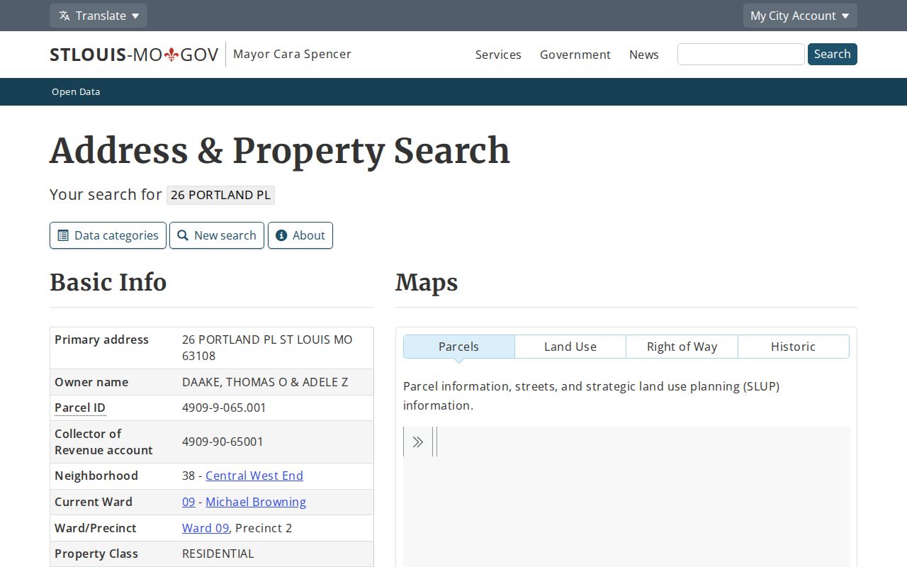
The parcel screen shows why the assessor result is an address starting point: it supplies several identifiers that can be carried into deeds, mapping, and permit research without treating one result as a household list.
St. Louis Address Record Terms
Street records use terms that look alike but answer different questions. Labeling them carefully prevents an old number, a correspondence address, or a plat reference from being mistaken for proof of current residence.
- Parcel
- A City property identifier that joins the address result to assessment, mapping, and related property information.
- Situs address
- The physical location of the parcel. It can differ from the owner’s mailing address.
- Plat
- A recorded map or subdivision reference that helps identify a block, lot, or tract when street names or numbers change.
- Criss-cross directory
- A reverse directory arranged by address, used to locate a listed occupant or business when the name is unknown.
For a historical address, the legal description or City Block/Lot can remain useful when the printed street label changes. The City warns that an online property description is not a legal document, so use the Recorder’s record when a legal copy is needed.
Map a St. Louis Street
The City GIS service makes address research geographic. Its MapServer presents layers for ZIP Codes, Neighborhoods, Wards, City Blocks, City Limits, zoning, and related boundaries. It supports JSON, GeoJSON, and PBF service formats, with service settings that cap queries at 2,000 records. Those formats describe map data, not a bulk resident export.
Use the map to identify the block and adjoining parcels, then look up each selected City address or parcel separately. A map click can provide geometry or a parcel reference, while the Address & Property Search provides the property result. The public inspection did not document a dedicated button to browse every address on a street, a resident export, or a guaranteed consumer map pop-up.
The official boundary service displays the layers used for this work.
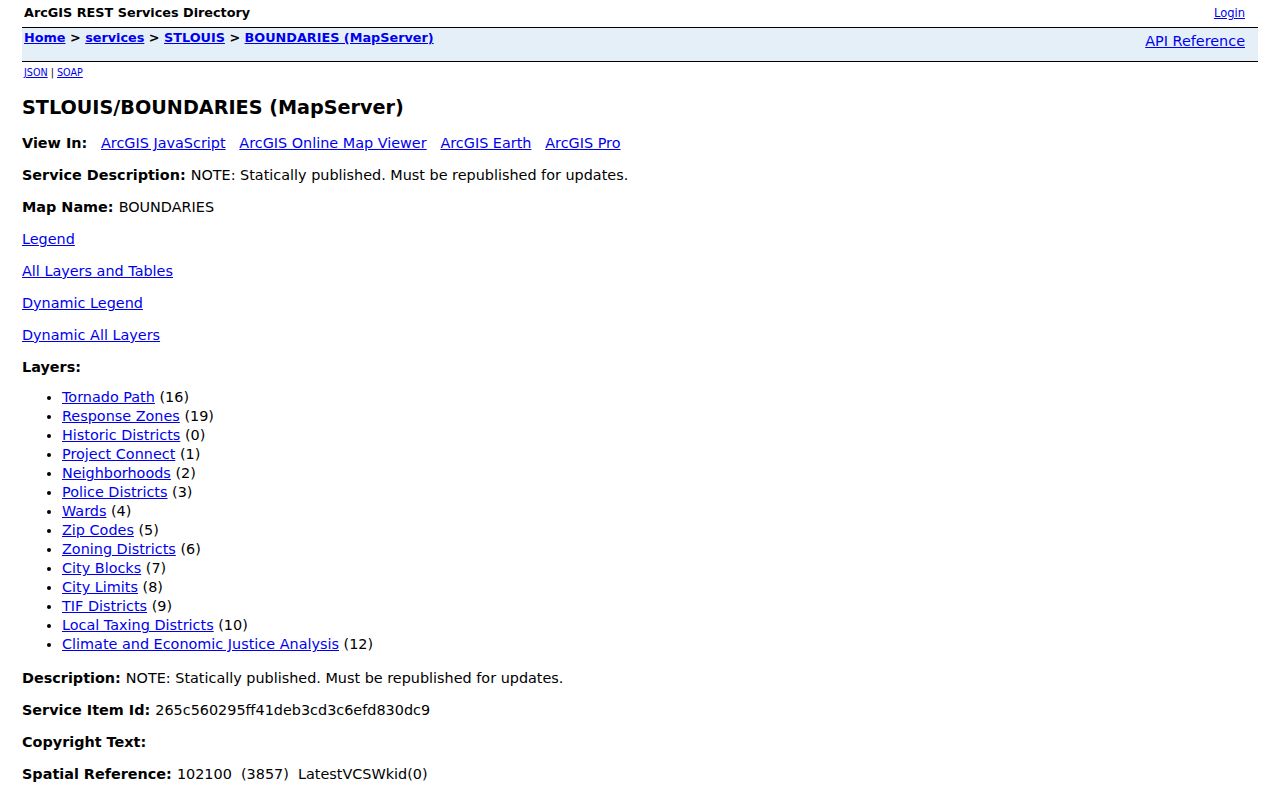
GIS is most useful for confirming whether an address lies in the City and for connecting a street to its parcel and boundary context before an assessor or recorder search.
St. Louis Records by Address
No single address source shows every person associated with a block. Each record contributes a different kind of evidence. Property and deed records describe ownership and instruments. Permits describe work at a location. Directories can preserve historical occupants. Voter information has its own statutory limits. Reading the rows together is more reliable than stretching one record beyond its purpose.
| Address source | City keeper | Street-level evidence | Access path |
|---|---|---|---|
| Address and property result | City Assessor / City data | Owner, mailing and situs addresses, parcel, account, geography, permits | Free address or parcel search |
| GIS layers | City Planning / GIS | Parcels, blocks, ZIP, ward, neighborhood, city limit, zoning | Official map service |
| Recorded instruments | City Recorder of Deeds | Grantor, grantee, instrument date, legal description, liens, plats | Free index, paid copies or counter help |
| Building permits | City Building Division | Address, owner, contractor, permit type, date, description, inspections | Address or parcel search and open data |
| Voter lookup or file | City Board of Election Commissioners / State | Registered-voter verification and district clues | Exact-field lookup or lawful request |
| Reverse directory | Library holdings | Listed historical occupant or business by address | Print, microfilm, or microfiche |
Property ownership is not the same thing as occupancy. A recorded deed can name a trustee, estate, lender, corporation, or spouse. A directory entry can be an address clue from its year, not proof for a different year. Keep those labels visible in a street-by-street research log.
Trace St. Louis Street Deeds
After the parcel result is in hand, move to the City Recorder. Search DirectSearch with the current owner as grantee, or use the address, parcel, book and page, or legal description. The purchase instrument identifies a grantor. Search that party as a grantee in an earlier period, then repeat while comparing dates and legal descriptions.
City guidance identifies July 1982 to the present as the main online workflow for address, grantee, grantor, and parcel help. Earlier research may require the Recorder or Assessor counter, public computers, older books, book-and-page references, or the Recorder’s mail request procedure. A missing online result is not evidence that an earlier deed never existed.
The Recorder DirectSearch landing page is the online index route.
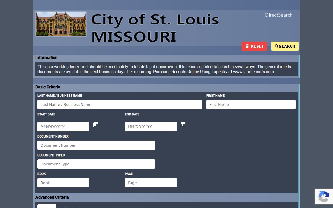
Use the index to capture parties, instrument type, recording date, book and page or document number, legal description, and copy availability before requesting an image or certified record.
St. Louis Street Permit Clues
Permits add dates and physical context to an address history. The City Building Division’s permit search accepts a City Street Address or Parcel. Its records can show a property owner, contractor, type, issue or status date, description, and inspections. They can help place a construction, demolition, or alteration event on a street timeline.
The researched instructions do not establish a complete historical start date, export procedure, hidden result sort, or pagination limit. The City reported a new online permit portal in March 2026, so field labels and workflow may change. A permit identifies work and associated parties. It does not prove who occupied the address at the time.
Verify a St. Louis Street Voter
Missouri’s online voter route is for an exact registration check, not for browsing names along a St. Louis street. The inspected state form requires registered first name, last name, date of birth, last four SSN digits, and county. City guidance also describes an address-based route that may need a name, house number, street name without street type, date of birth, and county. For a nonstandard address, the City Board of Election Commissioners directs people to call or visit.
RSMo 115.157 identifies public voter fields such as name, year of birth, address, ward, and precinct. Full file access may be requested under the statutory rules, but the online system is not a complete list and the research does not support using the St. Louis County fee schedule for City files. Safe at Home addresses, full dates of birth, SSNs, and ballot choices are not public street-directory fields. Missouri law also prohibits commercial use of voter data.
Note: A matching registration record can verify limited election information, but it cannot account for every person at an address.
St. Louis Street History
For older street work, the library shelves are the practical fallback. The St. Louis County Library holds city directories beginning in 1821, annual city microfilm from 1864 through 1931, selected later volumes through 1980, and a documented reverse section in the 1922 directory. The reverse arrangement begins with a number and street, which makes it a useful bridge from an address to a listed historic occupant or business.
The City and County split matters here too. The City separated from the County in 1876 and 1877, so a historical record labeled St. Louis can have a different modern custodian. Pair old directory entries with same-era maps and legal descriptions. The federal census release rule is 72 years, and a census address should be reconciled with a directory or map from the same period.
Historical address research belongs with the St. Louis Directory Book when the task is to read the collections themselves. For a street trail, use the reverse section as one carefully dated source among maps, deeds, and directory entries.
St. Louis Street Geography
St. Louis City is an independent city, not part of St. Louis County. That local geography shapes every address search. A ZIP, a postal city line, or a neighborhood name does not select the records custodian. Check the City Limits layer and the municipal field before relying on City property, Recorder, election, or permit records.
Wards, precincts, neighborhoods, ZIP areas, blocks, and city limits are separate layers. The City recognizes 79 official neighborhoods, but those boundaries do not exactly match ZIP or ward lines. A parcel can be oriented with all of them without turning any one geographic label into a residency claim.
When the City address service is unavailable, use the City Recorder counter, library directory holdings, City mapping office, or a focused Missouri Sunshine Law request to the proper custodian. Under RSMo Chapter 610, a custodian should respond as soon as possible and no later than the end of the third business day, or explain a delay. A request should state the record, date range, preferred format, and whether copies are wanted.
St. Louis Street Names Change
Do not assume a failed modern search ends an old address trail. French or German spellings, ward changes, annexation context, renamed streets, and number changes can separate one historic description from its current address. The research did not locate a confirmed citywide renumbering year, so no single renumbering rule should be applied.
Instead, bridge the gap with City Block/Lot, a legal description, a subdivision, adjacent addresses, book and page, or a same-era map. The Missouri Historical Society’s address search accepts an optional number and a street name without the suffix. Its `12**` wildcard can search the 1200-series. That is a useful historical index technique, not proof that every address in a range refers to the same parcel.
Limits of St. Louis Street Records
Address research can show public property, mapping, permit, instrument, and historical-directory evidence. It cannot reveal every household member, utility customer, private membership list, delivery recipient, or protected person. DMV addresses are closed under the federal Driver’s Privacy Protection Act. Safe at Home participants may use a substitute address, and protected court or election material may be withheld.
Use address research for family history, estate questions, property history, civic context, or confirming a record with its custodian. Do not infer a living person’s presence from an owner, mailing address, permit party, or old directory entry without a time-appropriate source.
Lawful use. St. Louis address records support personal, lawful research and must never be used to stalk, harass, or harm a person. Respect protected addresses and ask the custodian when an access limit is unclear.